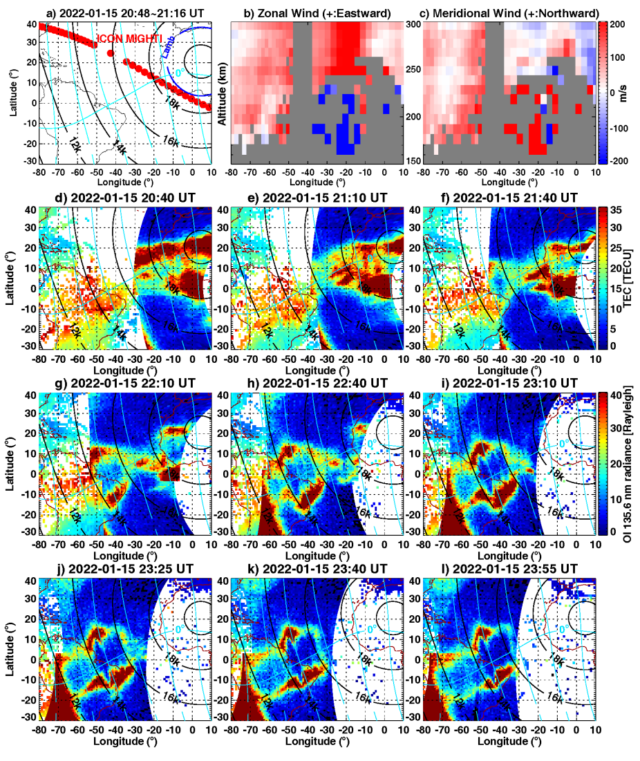
Following the 2022 Tonga Volcano eruption, dramatic suppression and deformation of the equatorial ionization anomaly (EIA) crests occurred in the American sector ∼14,000 km away from the epicenter. The EIA crests variations and associated ionosphere-thermosphere disturbances were investigated using Global Navigation Satellite System (GNSS) total electron content (TEC) data, Global-scale Observations of the Limb and Disk (GOLD) ultraviolet images, Ionospheric Connection Explorer (ICON) wind data, and ionosonde observations. The main results are as follows: (1) Following the eastward passage of expected eruption-induced atmospheric disturbances, daytime EIA crests, especially the southern one, showed severe suppression of more than 10 TECU and collapsed equatorward over 10◦ latitudes, forming a single band of enhanced density near the geomagnetic equator around 15–17 UT, (2) Evening EIA crests experienced a drastic deformation around 22 UT, forming a unique X-pattern in a limited longitudinal area between 20–40◦W. (3) Thermospheric zonal winds showed long-lasting quasi-periodic fluctuations between ±200 m/s for 7–8 hours after the passage of volcano-induced Lamb waves. The EIA suppression and X-pattern merging was consistent with a westward equatorial zonal dynamo electric field induced by the strong zonal wind oscillation with westward reversal.

(a–c) ICON MIGHTI track and corresponding zonal wind and meridional wind profiles between 20:48–21:16 UT on 15 January 2022. The iso-distance circles away from the Tonga eruption epicenter are shown in black lines. The blue circle in (a) is the estimated wavefront location of volcano-induced Lamb waves. (d–l) Combined GNSS TEC and GOLD OI 135.6-nm radiance maps in successive disk scan during 20:40–23:55 UT. The dip equator and meridional field lines are shown in cyan.